
Introduction
A study conducted by the Indian Space Research Organisation (ISRO) and published in NPJ Natural Hazards provides a forensic analysis of the August 2025 flash flood that destroyed Dharali village in Uttarakhand. The investigation identifies the primary cause as the collapse of an ice patch on the Srikanta Glacier, a phenomenon directly linked to ongoing deglaciation in the Himalayan region.
The findings underscore a critical shift in cryospheric hazards: while regional monitoring has traditionally focused on Glacial Lake Outburst Floods (GLOFs), this study highlights that smaller, under-recognised instabilities, specifically exposed ice patches in nivation zones, pose a significant and growing threat. The study advocates for an expanded monitoring framework utilizing high-resolution satellite imagery and topographic analysis to provide early warnings for downstream communities.
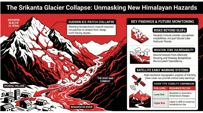
Geographical Context and Site Profiles
The study focuses on a ridge-to-valley system located within the upper Bhagirathi river basin in the Uttarkashi district of Uttarakhand.
Srikanta Glacier
Classification: A small to medium-sized valley glacier.
Elevation: Reaches a height of 6,133 meters.
Location: Situated approximately 9.8 km upstream of Dharali village.
Topography: Characterized by steep accumulation and ablation zones, seasonal snow cover, and extensive nivation areas.
Current Status: Identified as a retreating glacier significantly impacted by warming temperatures and deglaciation.
Dharali Village
Hydrological Position: Located downstream of the Khir Gad stream, which originates at the Srikanta Glacier.
Vulnerability: The Khir Gad stream bisects the village into right- and left-bank settlements before joining the Bhagirathi River. This positioning places the entire village at high risk for flash floods originating from the glacier.
Technical Analysis of the Flash Flood
The Mechanics of Ice-Patch Collapse
The August 2025 disaster was triggered by the sudden detachment of a mass of glacier ice. These collapses typically occur on steep slopes or within the nivation zone—the area where ground erosion occurs beneath and around snow banks due to alternating freezing and thawing cycles.
Factors Influencing Stability
The study distinguishes between two types of ice based on their stability:
Resistant Ice: Ice patches covered by firn (multi-year snow) and seasonal snow are relatively stable and resistant to short-term temperature fluctuations.
Unstable Ice: Exposed ice patches, resulting from thinning seasonal snow and firn cover, are highly susceptible to shifting or loosening. Pre-event satellite imagery revealed exposed ice on steep north- to northeast-facing slopes during the ablation period (the phase when glaciers lose mass).
Research Methodology and Findings
ISRO researchers utilized a multi-faceted approach to reconstruct the event and identify the causal link between deglaciation and the flood.
Method | Application |
Satellite Observation | Used to identify pre-event exposed ice patches and track the sequence of the collapse. |
Topographic Analysis | High-resolution mapping of the ridge-to-valley system from the glacier to the river junction. |
Visual Records | Used to confirm the physical impact and the path of the flood through the Khir Gad stream. |
Key Findings
Direct Causation: The flash flood was unequivocally triggered by the collapse of an ice patch in the nivation area of the Srikanta Glacier.
Climate Linkage: The thinning of snow and firn cover, which exposed the unstable ice, is consistent with regional warming and deglaciation trends.
Hazard Expansion: The study identifies "exposed ice patches" as a previously under-recognized risk factor in Himalayan glacial hazards.
Strategic Implications for Disaster Management
The ISRO study suggests a fundamental reorganization of how glacial hazards are monitored and managed in the Himalayas.
Expansion of Monitoring Scope
The current focus on Glacial Lake Outburst Floods (GLOFs) is insufficient to capture the full spectrum of risks. Monitoring must now include:
Small-scale cryosphere instabilities.
Exposed ice patches on steep slopes.
Nivation zones during the ablation period.
Early Warning Systems (EWS)
The value of pre-event satellite monitoring is paramount. By identifying exposed ice patches that persist during the ablation period, authorities can gain early indicators of potential disasters. This data is vital for:
Climate Risk Understanding: Improving the accuracy of long-term climate impact models.
Disaster Preparedness: Providing downstream communities, like Dharali, with the necessary lead time to mitigate loss of life and property.
Informed Infrastructure Planning: Assessing the safety of settlements located along high-risk streams like the Khir Gad.